Building near Western Sydney International Airport: what you need to know
Western Sydney International (Nancy-Bird Walton) Airport at Badgerys Creek is Sydney's second major airport, and unlike Sydney Airport it has no curfew. If you own land or plan to build within about 30 km of it, the planning rules are stricter than around Sydney Airport: close to the airport, most new homes can't be approved at all.
This guide covers what the airport is, how the flight paths work, the planning rules for building near it, and the Australian Government's noise insulation program for existing homes.
The airport in brief
- Runway. One runway, 3.7 km long, running north-east to south-west. A second parallel runway is planned for the long term; the environmental impact statement expects it to be needed around 2055.
- Hours. It operates 24 hours a day with no curfew, and it's intended to be Sydney's airport for overnight freight.
- Capacity. Stage 1 is designed for up to 10 million passengers a year.
Flight paths
The flight paths went through a full environmental assessment. The draft environmental impact statement (EIS) was on exhibition from October 2023 to January 2024 and drew more than 8,000 submissions. The final EIS was published in November 2024, the federal Minister authorised the airspace design in June 2025, and the flight paths took effect on 9 July 2026.
By day the preferred direction is Runway 23: aircraft arrive from the north-east and take off towards the south-west. At night, when conditions allow, the airport uses Reciprocal Runway Operations, sometimes called head-to-head: aircraft both take off to and arrive from the south-west, which keeps them away from the more populated areas to the north-east. A Ministerial direction makes this the preferred night mode. It only runs when the tailwind is light, the runway is dry and traffic is low, so it won't cover every night or every hour of the night.
The EIS found that the night mode is likely to increase noise for The Oaks, Warragamba, Silverdale, Cobbitty, Greendale, Hazelbrook and Linden, and reduce it for St Marys, St Clair, Kingswood, Jordan Springs, Werrington and Orchard Hills.
To see what to expect at a particular address, use the government's Aircraft Overflight Noise Tool. It shows indicative aircraft heights, forecast numbers of flights and noise maps for any address. You can also watch flights live on Airservices' WebTrak.
The planning rules
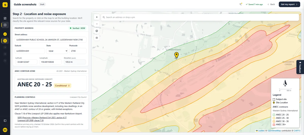
The key rule is section 4.17 of the State Environmental Planning Policy (Precincts—Western Parkland City) 2021. It says development consent must not be granted for noise sensitive development on land in an ANEF or ANEC contour of 20 or greater. These airport safeguards reach beyond the Aerotropolis itself, to land up to 30 km from the airport, whichever council it's in.
"Noise sensitive development" is broad. It includes residential accommodation of all kinds, child care centres, schools and other educational establishments, hospitals, places of public worship, exhibition homes and a few other uses. The rule also overrides the state policies that would otherwise allow some of these, such as seniors housing.
The exceptions
There are a few narrow exceptions inside the contour:
- A dwelling house on a vacant lot, where there was no dwelling on the land and a dwelling house was already permitted when these controls began. The council must be satisfied the house will meet the indoor design sound levels in Table 3.3 of AS 2021:2015.
- A secondary dwelling (granny flat) of up to 85 m² on land in the ANEC 20–25 contour in the Camden, Fairfield, Liverpool, Penrith or Wollondilly council areas. This was added in May 2026. It too has to meet the AS 2021 indoor levels, and the council must consider the state's Aviation Safeguarding Guidelines.
- Subdivision where the development application was made before 1 October 2020.
If you're planning alterations, additions or a knock-down rebuild on land inside the contour, talk to the council before you design anything. The prohibition is broad and the exceptions are specific.
ANEC or ANEF?
Most airports are planned around an ANEF, the official forecast noise map. The SEPP maps around Western Sydney instead use an ANEC, a concept map, drawn for the airport's long-range future with two parallel runways. That's why the contours are wider than you'd expect for an airport with one runway. WSI now also has an endorsed ANEF, prepared with its master plan, which covers single-runway operations. The NSW Aviation Safeguarding Guidelines say both should be considered. There's more on the difference in What is ANEF?
Which areas are inside the contour
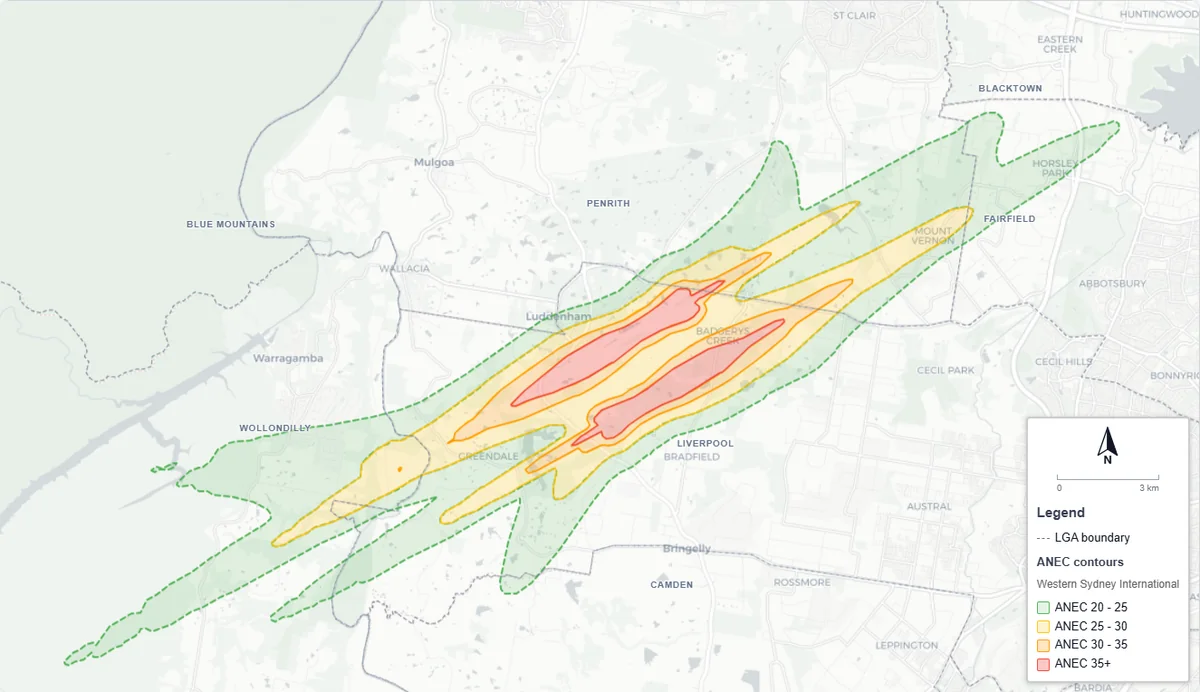
The ANEC 20 contour runs in a long band north-east to south-west through the airport site. According to the EIS, the homes inside the SEPP's ANEC 20 contour are in Luddenham Village (generally south-east of Blaxland Avenue), the eastern fringe of Silverdale, the Twin Creeks estate, and scattered rural-residential properties in Luddenham, Badgerys Creek and Greendale. Very few residents are inside ANEC 25, mostly in Greendale.
Other rules that may apply
- Western Sydney Aerotropolis. Inside the Aerotropolis, the Phase 2 development control plan requires development in ANEC 20 or higher, including extensions, to achieve the AS 2021 indoor levels. You can either use the deemed-to-satisfy constructions in the DCP or provide an acoustic report.
- Western Sydney Employment Area. Section 2.36 of the Industry and Employment SEPP bars residential development, child care, places of worship and TAFE establishments in ANEF or ANEC 20 or higher where the Western Parkland City rules don't apply.
- Low and mid-rise housing reforms. The state's low and mid-rise housing provisions and pattern book homes don't apply on land in ANEC 20 or higher, or ANEF 25 or higher.
- Rezoning. A Ministerial planning direction stops planning proposals from adding residential zoning or density inside the WSI 20 ANEC/ANEF contour.
The Aviation Safeguarding Guidelines also encourage councils to tell applicants in writing about future aircraft noise, note it in development consents, and consider covenants that limit later complaints about airport noise.
If you're buying near the airport
The section 10.7 planning certificate for a property has to say whether the land is in an ANEF or ANEC contour of 20 or greater under the SEPP. Ask for it before you commit.
Outside the contours, you may still hear plenty of aircraft. The EIS forecasts that by 2055, between 7,000 and 12,200 residents could experience five or more aircraft noise events above 70 dB(A) a day, and between 23,500 and 84,500 could experience two or more events above 60 dB(A) at night, depending on how often the night mode is used. Our guide ANEF vs N70 explains these "number above" figures.
AS 2021 itself notes that communities newly exposed to aircraft noise tend to react more strongly than those used to it.
The WSI Noise Insulation Program
The Australian Government is funding noise insulation for eligible existing homes and community buildings near the airport. Full details are on the WSI Noise Insulation Program website, including its resources and FAQs page.
Who's eligible
Eligibility is based on the ANEC 20 composite contour for the year 2040 from the 2024 EIS, which is a different map from the one in the SEPP. A lot counts if the contour touches it, with some extra properties added where a road, creek or similar forms a natural boundary, and some street-based adjustments in Luddenham Village and Twin Creeks. Buildings more than 1 km from the contour are excluded. You can check an address on the eligibility page or in the detailed eligibility maps. Being inside the area doesn't make a property eligible automatically.
Eligible buildings are homes and units used for living in, whether owner-occupied, rented or second homes, plus schools, child care centres, health and medical facilities and places of worship. Not eligible: caravans and movable homes, unapproved buildings, commercial, retail and industrial buildings, properties due to be acquired by government, and buildings that were already required to include noise insulation as a condition of their approval. Buildings must have been built before the program started.
That last point matters if you're building now. A new home approved inside the contour has to meet the AS 2021 indoor levels as a condition of consent, so the insulation is part of your build, not something the program will pay for later.
What's included
Only noise-sensitive rooms are treated: bedrooms, living rooms and studies or home offices. Treatments can include:
- sealing gaps around doors and windows
- replacing single-glazed windows with acoustic glazing
- replacing hollow-core external doors with solid-core doors
- acoustic insulation in ceilings and roofs, and enclosing open eaves
- treating poorly performing skylights
- ventilation or air conditioning so the house stays comfortable with the windows shut
The aim is to bring the worst-case aircraft noise inside down to about 50 dB(A), though the program guidelines describe this as a non-binding target. The government covers the acoustic assessment, design, supply and installation, approvals, inspections and warranties, up to a cost cap per building. Owners pay for any extra upgrades they ask for, and for repairs needed to make a building safe before work starts.
How to apply
Applications opened in April 2026 and stay open until April 2028. Owners apply online through the application page, with a 100-point identity check and proof of ownership. Tenants can't apply for homes. If accepted, there's an on-site assessment, a noise treatment plan agreed with the owner, the works themselves (typically four to six weeks), and a final noise test. The how to apply page and the program guidelines have the detail. Questions go to wsinoiseinsulation@infrastructure.gov.au.
What this means if you're building
- Inside the ANEC 20 contour: first confirm with council whether one of the exceptions covers your project. If it does, you'll need to show the design meets the AS 2021 indoor levels, which usually means an aircraft noise report.
- Inside the Aerotropolis: extensions and other development in ANEC 20 or higher need to meet the same indoor levels, either through the DCP's deemed-to-satisfy constructions or a report.
- Outside the contours: there's usually no aircraft noise requirement, but check the noise tool anyway. With 24-hour operations, and a second runway in the long-term plan, some owners choose better glazing and a quieter ceiling anyway. It's far cheaper to do at the build than to retrofit.
QuietPath's free check maps the SEPP's ANEC contours around Western Sydney International and shows the planning rule for your council area. When you need a report, a Resonate acoustic engineer prepares it from your drawings.
Sources and useful links
- Prime Minister of Australia, Western Sydney to open for passengers on 25 October, 10 June 2026.
- Department of Infrastructure, Western Sydney International Airport flight paths.
- WSI flight paths, final environmental impact statement (Chapter 11 Aircraft noise; Chapter 14 Land use).
- Airservices Australia, Western Sydney International community hub, including the reciprocal runway operations factsheet.
- SEPP (Precincts—Western Parkland City) 2021, section 4.17.
- NSW Department of Planning, Aviation Safeguarding Guidelines, May 2026.
- WSI Noise Insulation Program: resources and FAQs, program guidelines.
- Airservices Australia, making an aircraft noise complaint.