What is ANEF? Reading an aircraft noise contour map
ANEF stands for Australian Noise Exposure Forecast. It's a map of how much aircraft noise the land around an airport is expected to get, drawn as contour lines labelled 20, 25, 30, 35 and 40. If you're building near an airport, the ANEF band your site falls in is usually the first thing council looks at.
What the numbers mean
An ANEF number isn't a decibel reading, and it doesn't tell you how loud a single plane will be. It's an index of total noise exposure over an average day, worked out from a forecast of a whole year of flights. It rolls three things into one number:
- how loud each type of aircraft is on each flight path, measured in a unit that also accounts for the tone and duration of the noise
- how many flights there are of each type on each path
- when they happen, with flights between 7 pm and 7 am counting four times as much as daytime flights
The number of flights goes into the formula on a logarithmic scale, so doubling the flights adds about 3 to the ANEF. A higher number always means more noise exposure, but the scale isn't linear: ANEF 30 is a lot more exposure than ANEF 25.
What each band means for building
The Australian Standard for building near airports, AS 2021, describes the bands this way:
- Outside ANEF 20. Noise from other sources, like traffic, tends to dominate, though some people still react strongly to aircraft noise.
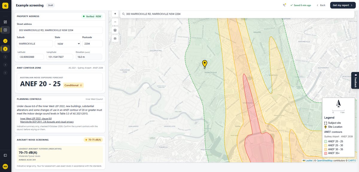
- ANEF 20 to 25. Aircraft noise starts to emerge as an environmental problem.
- Above ANEF 25. Exposure becomes progressively more severe.
For a house, AS 2021 treats a site below ANEF 20 as acceptable, ANEF 20 to 25 as conditionally acceptable (it can go ahead if it's built to keep aircraft noise out), and above ANEF 25 as unacceptable for new building. Other building types have different thresholds. Most NSW councils near airports have a planning rule that kicks in at ANEF 20 and requires new homes to meet the standard's indoor noise levels. Our guide What is AS 2021? has the full table.
The ANEF 20 line is shown dashed on official charts because it's the least certain. Real flight paths spread out, and the further you get from the airport the harder the line is to place. AS 2021 allows the conditionally acceptable process to be used for sites outside but near ANEF 20 for this reason.
Where the ANEF system came from
The ANEF system is an Australian version of the US Noise Exposure Forecast. In 1979 the federal government commissioned the National Acoustic Laboratories to survey how people living near airports reacted to aircraft noise. The study, published in 1982, interviewed 3,575 residents around the airports in Sydney, Adelaide, Perth and Melbourne, and RAAF Base Richmond.
It found that people's reactions lined up best with total noise exposure, rather than the loudness of individual flights, but that the American system weighted night flights too heavily and evening flights not at all. The Australian version moved the night period to 7 pm–7 am, cut the night weighting, and added the ANEF 20 contour to every chart. ANEF 25 was recommended as the limit for residential land in 1985 and adopted as Commonwealth policy.
ANEF, ANEI and ANEC
The same modelling produces three kinds of noise map, and they're easy to mix up:
| Chart | What it shows | Used for planning? |
|---|---|---|
| ANEF (forecast) | Forecast noise exposure for a future year, often around 10 years out or the airport at its ultimate capacity. | Yes. It's the only one meant for land use planning, and only one ANEF is current for an airport at a time. |
| ANEI (index) | Actual noise exposure in a past year, using the real flights that took place. | No. Used to track change over time. |
| ANEC (concept) | Noise exposure for a hypothetical scenario, such as a proposed runway or airport. | Not under AS 2021, though there are exceptions in practice (see below). |
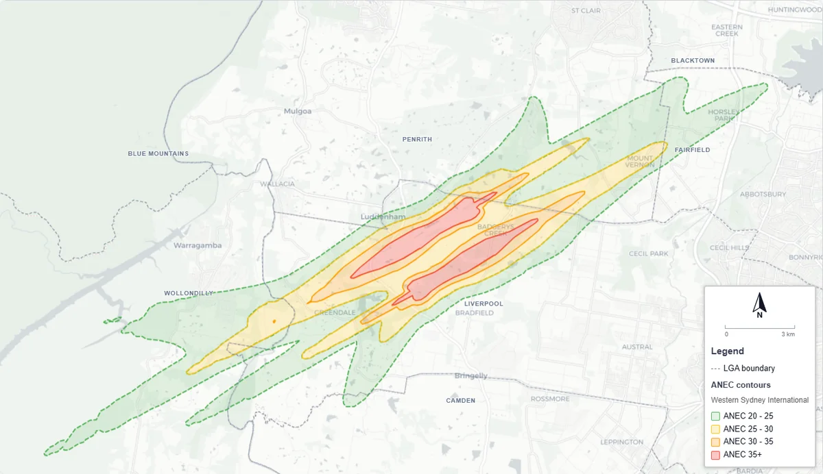
The main exception in NSW is Western Sydney International. The state's planning controls around the new airport use a long-range ANEC that allows for a future second runway. The airport's own endorsed ANEF, in its master plan, covers single-runway operations, and NSW guidance says both should be considered. See Building near Western Sydney International Airport.
Who makes ANEF maps
Airports prepare their ANEFs, and for civil airports Airservices Australia endorses them for technical accuracy. It checks that the aircraft types, runway use, flight tracks and forecast numbers are realistic and that the contours have been modelled correctly. For military airfields such as RAAF Williamtown and RAAF Richmond, the Department of Defence prepares and endorses the ANEF, and Defence's ANEFs include civil flights that share the airfield.
Federally leased airports have to include an ANEF in each master plan. Sydney, Western Sydney International, Melbourne, Brisbane and Perth must produce a new master plan every five years; other leased airports, such as Bankstown and Camden, every eight years. Only one ANEF is current at a time, and a newly endorsed one replaces the last.
An ANEF doesn't lapse when its forecast year passes; it stays in use until a new one is endorsed. Defence's ANEF for RAAF Williamtown is a forecast for 2025, endorsed in 2011, and its ANEF for RAAF Richmond is a forecast for 2014, endorsed in 2004. Both are still the only ANEF maps Defence lists for those bases.
What an ANEF map won't tell you
- How loud a plane will be at your house. That's a different measure, the maximum noise level of a flyover in dB(A). AS 2021 works it out separately from the site's distance to each runway and the aircraft types forecast to use them.
- When the noise happens. An ANEF averages a whole year. Runways change direction with the wind, so a site can have busy days and quiet days that the average hides.
- Whether you'll notice planes outside ANEF 20. You may well. Federal guidance on aircraft noise notes that most complaints come from people living outside the ANEF 20 contour, and that noise doesn't stop at a line on a map. That's why airports also publish maps of how many flights exceed a set noise level. Our guide ANEF vs N70 explains those.
How to find your site's ANEF
Airservices suggests getting the endorsed ANEF from the airport or your council. In NSW the main sources are:
- Sydney Airport: the airport's current master plan.
- Western Sydney International: the ANEC contours in the NSW Planning Portal's Western Sydney Aerotropolis layers, and the ANEF in the airport's master plan.
- Bankstown and Camden: the master plans published by the airports' operator, Aeria.
- RAAF Williamtown (and Newcastle Airport), RAAF Richmond and HMAS Albatross: Defence's aircraft noise page.
- Regional airports: usually the council's LEP maps or website.
The quickest way to check a NSW address is QuietPath's free check. It maps the contours for Sydney Airport, Western Sydney International, Newcastle Airport and RAAF Williamtown, RAAF Richmond, Cessnock and Scone, and shows the council's aircraft noise rules alongside. It tells you which band the site is in and what that means for a new home.
Sources
- Standards Australia, AS 2021:2015 Acoustics—Aircraft noise intrusion—Building siting and construction, Clause 1.5.6, Table 2.1 and Appendix A.
- Hede, A.J. and Bullen, R.B., Aircraft Noise in Australia: A Survey of Community Reaction, National Acoustic Laboratories Report No. 88, 1982.
- Airservices Australia, ANEFs and ANEIs and Considering aircraft noise when buying a home.
- Airports Act 1996 (Cth), sections 71 and 76.
- Department of Infrastructure, National Airports Safeguarding Framework, Guideline A attachment: Supplementary aircraft noise metrics, 2016.
- Department of Defence, Aircraft noise monitoring and reporting.